 SimpleDEMViewer
SimpleDEMViewerAS
About
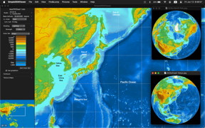
SimpleDEMViewer browses DEM ( Digital Elevation Model ) data as a relief map. It displays colored map with shading. Since no data is included in this package, user should prepare DEM data separately.
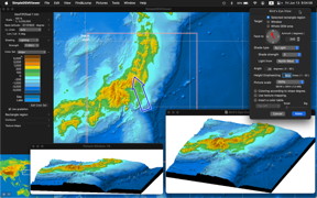
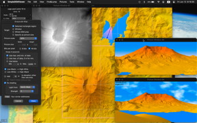
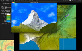
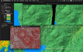
SimpleDEMViewer draws bird's-eye view, stereographs, panorama view, grayscale map, orthographic, Mercator and other projection maps.
Mac App Store version SimpleDEMViewerAS is available. Some restrictions are added because of Mac App Store technical requirement.
DEMs supported
GTOPO30, HYDRO1K, SRTM, SRTM DTED, SRTM30plus, ETOPO1, ETOPO2, ETOPO5, GLOBE, GDEM, GeoTiff, netCDF, PDS DEM, some BIL forms, USGS Ascii, USGS SDTS, ArcInfo Ascii, DEMs from GSI of Japan.
Functions
- Displays color elevation map in a window with or without shading.
- Draws lakes. User can create lake data for various DEMs.
- Draws contour lines on the color elevation map.
- Makes Conical, Orthographic, Mercator, Azimuthal Equidistant and Azimuthal Equal-Area projection maps.
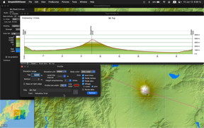
- Makes Bird's-eye view pictures, stereographic pictures, profile charts.
- Makes Panorama view. ( V4 )
- Colorizing visible region from some point. ( V4 )
- Measure mileage along any path. ( V4 )
- Creates memo to show mark and strings on the map.
- Memos can show pictures, movies or web pages.
- Creates routes and area data on the map.
- Saves pictures as files in any format that Image Kit supports, or as PDF.
- Show any place in Apple's "Maps" or "Google Map" pointed on the map window. ( V5 )
- Read simple Placemark of KML file as user memo data. ( V5 )
- Supports Lambert Conformal Conic projection map. ( V5 )
- DEM Inspector supports to amend each elevation value. ( V5 )
- Export new DEM data file of bil form. ( V5 )
- Supports adding and updating strings on picture windows. ( V5 )
- Supports 3D movie. You can flight or cruise in landscape. ( V5.5 )
- Supports shading by slope. (V5.8)
- Supports planet DEMs. (V6.1)
- Pictures can contain color table, they are main window image, projection maps and bird's eye view. (V6.2)
- Add letters of latitudes and longitudes into main window image picture, (6.2) and projection maps. (6.4)
- Support drawing contour as lines, so that some draw software can treat contour as lines later. (6.4)
- Support SRVC Relief Map. (6.6)
- Supports world's local plane coordinate systems. (6.7)
- Exports / imports User Data to / from text files. (6.7)
- Save pictures as GeoTiff. (6.8)
- Index window supports UTM and other plane DEMs. (6.8)
- Projection map supports separate projection center from picture center. (6.9)
- Supports Apple Silicon ( M1 ) Mac natively. (7.0)
- Contour lines above sea level can be set individually. (7.0)
- Reposition main window map by double clicking on the index Map. (7.0)
- Supports more types of GeoTiff DEM files. (7.5, 8.2)
- The items that can be set in the Map Info Panel has been increased, making it easy to check effect of changes in shading, longitude lines, and other settings.(8.0)
- Supports lake and river of Aster GDEM version 3. (8.0)
- Supports joining User Route Data. (8.0)
- Supports tilting User Data strings, and vertical writing. (8.0)
- Supports function that adds user-specified route data (such as the administrative boundaries) and arbitrary strings (country names, etc.) to the Index Map. (8.0)
- Support measuring volume of islands and mountains, and measuring valley capacity for dam. (8.3)
- Supports Dock Menu to activate program with specifying Named Working Set. (8.4)
- Supports clouds and waves of Panorama View. (8.5)
- DEM Inspector supports larger extent up to 11 by 11. (8.5)
Requirement
Version 8 and AS 3 : macOS 12 or newer
Version 7 and AS 2 : macOS 10.14 or newer
Version 6 : macOS 10.11 or newer
Screen shots
Download
Program

SimpleDEMViewerAS 3.5.2
Click picture at right to download from Mac App Store.Download SimpleDEMViewer 8.5.2 ( 10.8 MB ) Nov. 21, 2025
Download User manual V.8.5 ( 21.0 MB )Download SimpleDEMViewer 7.5.9 ( 9.8 MB ) Aug. 27, 2024
Download User manual V.7.5 ( 16.1 MB )Download SimpleDEMViewer 6.9.3 ( 7.3 MB ) Mar. 27, 2021
Download User manual V.6.9 ( 11.2 MB )Sample data
Download World Boundaries and Rivers : worldBoundary.zip ( 49 MB )
Includes type3 ( sdrout ) and type 4 ( jzrout ).
User route data derived from 'World Boundary Databank II'Download Coastlines, Islands and Lakes : worldCoast.zip ( 46 MB )
Includes type3 ( sdrout ) and type 4 ( jzrout ).
User route data derived from 'World Boundary Databank II'Download world sea names. SeaNames.zip 7 kB
Includes type3 ( sdmemo ) and type 4 ( jzmemo )Download Memo marks. MemoMarks.zip 44 kB
Sample memo marks for any version.
Release notes
SImpleDEMViewerAS 3.5.2 ( Nov. 21, 2025 )
Following items are different from SimpleDEMViewer 8.5.1
- Does not support DEMs from GSI of Japan, those have file extension ‘LEM’.
- You should select directory instead of individual files for SDTS and JAXA ALOS DEMs.
- All tiff format files can be selected by Open panel even if those files are not DEM files. They will be checked after you close the panel. netCDF files those have file extension ‘GRD’ are the same. Also bil form files are checked later if HDR file is exists or not.
- Cannot read alias files even they point DEM files if you select directory. You should select individual files for aliases.
- User Memo Data cannot show pictures, if referencing pictures reside outside Memo Library.
- Terminate application if you close the main window.
Version 8.5.2 ( Nov. 21, 2025 )
- If Color Set has seabed part, such as ETOPO, the sea pane will be excluded from the color table added to images.
- Correct following issues.
- Before macOS 26 Tahoe, world file's file type may not match with picture format when saving Map View picture.
- Other minor issues.
Version 8.5.1 ( Apr. 25, 2025 )
- Correct following issues.
- When importing user data from text file, their string attributes were linked, so individual changes were no longer possible after importing.
- The picture window has been moved behind the main window after saving it as a picture file.
- Width of the Panorama View showed invalid value in the info-panel when type is Anaglyph.
- Other minor issues.
Version 8.5.0 ( Mar. 23, 2025 )
- Panorama View supports clouds in the sky and waves on the sea.
- DEM Inspector supports larger extent up to 11 by 11.
- Correct following issues.
- Bird View and Grayscale Map may show invalid portion when geo-referenced DEMs and other plane DEMs are read.
- Program terminate abnormally when cancel Panorama View creation during drawing.
- Other minor issues.
Version 8.4.0 ( Feb. 9, 2025 )
- Supports selecting Working Set when starting this program from Dock. Working Set names will be displayed in the Dock menu.
- Exporting DEM function supports bigger than 2 GB output files
- Correct following issues.
- Could not read Big GeoTiff DEMs correctly if it is bigger than 2 GB and it is compressed internally.
- Could not wrote no-data tag ( GDAL_NODATA ) to GeoTiff DEMs.
- XYPLANE parameter was not included in the header file when exporting BIL form DEMs, when those are based on Japanese projection planes.
- Under macOS 15 Sequoia, Open panel could select DEMs they are read already.
Version 8.3.1 ( Jan. 10, 2025 )
- Correct following issues.
- Memory leaks as large as picture size occured after saving Map View picture.
- Could not scroll Map Info Panel when the cursor resides on the Color Set table.
- Short cut key commands to expand or shrink Map View was not available after clicking Color Set table items in the Map Info Panel.
- Other minor issues.
Version 8.3.0 ( Nov. 27, 2024 )
- Support measuring volume of islands and mountains, and measuring valley capacity for dam.
- Correct following issues.
- "Place nnn to all cells in frame" menu did not appear in the popup menu of the Map View during DEM Inspector, if DEMs are UTM or other planes.
- Other minor issues.
Version 8.2.0 ( Oct. 14, 2024 )
- Support GeoTiff for Planet DEMs.
- Shows radius of planets in the Map Info Panel.
- Shows direction from the start point when measuring mileage.
- Supports wider texture maps up to 360 degrees.
Version 8.1.0 ( Aug. 20, 2024 )
- Support removing individual DEM files.
- Support tilting text strings on the picture windows.
- Support font menu directly on the string setting dialogs.
- Correct following issues.
- Styles specified by Font Panel are always ignored.
- User data string will not draw correctly when reading from file, if shadow effect is specified.
- Other minor issues.
Version 8.0.3 ( June 14, 2024 )
- Correct following issues.
- Saved picture format of picture window ( except Panorama View and Topographic Profile ) may be different from specified by user. The file extension showed correct file format specified by user, but actual content was the format specified by user last time.
- File extension of the saved Topographic Profile showed correct file format specified by user, but actual file format was jpeg always.
- Word "GeoProfile" is replaced by "Topographic Profile" or "Topo-Profile".
Version 8.0.2 ( May 30, 2024 )
- Correct following issues.
- Pasting address string to address control could not do it correctly if input string contains '+' character before numbers, except ISO format.
- Pasting address string to address control could not do it correctly if input ( Japanese ) string contains full-width Arabic numerals.
- Window width of Stereographic Panorama View was restricted to the width of one pane, then you could not see it as stereograph.
- Panorama View could not create anaglyph image correctly.
Version 8.0.1 ( Apr. 12, 2024 )
- Correct following issues.
- Could not change lake data folder.
- Preferences panel behaved oddly under stage manager or full screen mode.
- "Other scale" menu showed 400% always in SRVC Relief Map dialog.
- Could not show the information panel for 16 bit Gray Scale Map window.
- Bucket cursor did not appear occasionally during creating lake data.
- Other minor issues.
Version 8.0.0 ( Mar. 9, 2024 )
- Increased the contents that can be set in the information panel of the map window, making it easy to check the changes in shading and other settings.
- Supports river and lake data of GDEM version 3.
- Extends support range of Base Latitude up to 70 degree.
- Replaces standard color set "Sea depth" with "wikiColor".
- Improved shading image of the Map View if shading type is by slope or slope and light, especially when strength is bigger number.
- Supports combining two Route data.
- Supports to reverse nodes of Route data.
- Supports rotation and vertical writing of User Data strings on the Map View.
- Search string function can search Memo content.
- Index Map supports boundaries and strings user specified.
- Index map can be hidden from Side Bar.
- Panorama view added setting option that treats void area of DEM as sea.
Known issues
About
DEMs supported
Functions
Requirement
Screen shots
Download
Program
Sample data
Release notes
Latest version
Older version
Known issues
Sample pictures
Gallery Jizoh
in Japanese (日本語)
Copyright 2004 - 2025 by Yoshiaki Katayanagi, all right reserved.
